
Work begins on robotic fleet
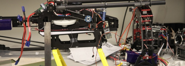
Construction has started on our robotic fleet of vehicles. The first acrobatic helicopter is an T-REX 450 PRO 3GX flybarless system to be used as a trainer craft. The 3GX is currently the smallest and lightest flybarless system on the market. This robotic fleet will be used for a variety of tasks including:
Thermodynamics of Tornadoes: Measuring the thermodynamics of the atmosphere in the vicinity of tornadoes to help improve both our tornado forecasts and our understanding of tornado-genesis.
Gas Leaks: Measuring the composition of the atmosphere to assist with leak detection.
Agriculture: Monitoring the health and size of cattle.
Secrets of a dynamic planet
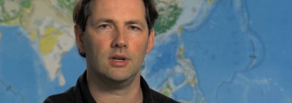
The University of Texas at Dallas geosciences team pursues a multidisciplinary program to understand Earth’s evolution.
Alexander Braun is using remote sensing (specifically, space geodetic satellite observation) to understand changes in Earth systems over time. “You can actually measure real physical parameters – such as the [Earth’s] gravity field or magnetic field – and, more importantly, you can detect surface deformation. The Earth is a very active planet and it is crucial for us to understand when and where it is moving.”
Carlos Aiken and colleagues, are using an approach called cybermapping (which integrates laser scanning, digital photography and satellite positioning, among other sensors) to build 3D photorealistic models of surface geology around the world. Their work is being applied in oil exploration and education (for virtual field trips).http://physicsworld.com/cws/article/multimedia/46833
Identifying Oil Spills
Grants from DoD & NIH
Aerosol in the lowest km
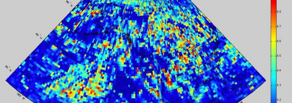
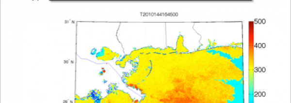
A key step in having a global daily PM2.5 data product for health and other applications is estimating what fraction of the total Aerosol Optical Depth (AOD) seen routinely by satellites is in the atmospheric boundary layer. The atmospheric boundary layer is the layer of the atmosphere closest to the surface where we generally live and breath. We have for the first time automated a process by which we can estimate the fraction of the total AOD in the lowest km of the atmosphere on a daily basis. We do this by taking every single NASA CALIPSO vertical profile and flying forward and backward trajectories from each point on the profile using a trajectory model.This is a massive number crunching exercise that we perform on our local computational cluster. This allows us to estimate the global 3D aerosol backscatter distribution on a daily basis. We then split the planet up into a regular grid (in the above example it is a 1×1 degree grid). For each grid cell we calculate the fraction, f, of the total backscatter which is in the lowest km. In the movie above we have animated the subset of our global analysis over just the USA for first six weeks of CALIPSO data.
Following from our prototype studies we have identified that the determination of the fraction, f, of the total aerosol extinction due to aerosols in the boundary layer is an important missing parameter needed to improve accuracy in the estimate of the PM2.5 abundance.


